
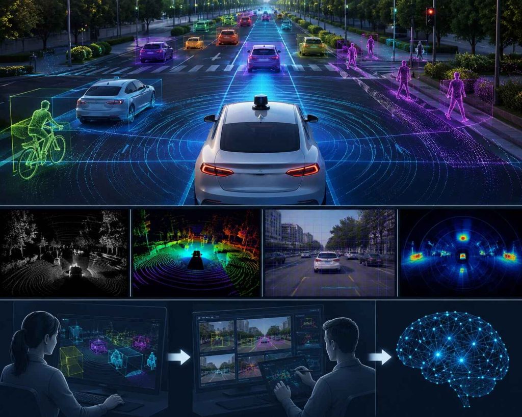
An autonomous vehicle doesn’t see the world the way a human driver does. It perceives the road through a fusion of cameras, LiDAR, radar, and ultrasonic sensors, each generating a continuous stream of raw data that means nothing to the vehicle’s perception system until it has been labeled, structured, and taught what it represents. A pedestrian stepping off a curb, a cyclist merging into a lane, a plastic bag blowing across the highway that shouldn’t trigger emergency braking — every one of these distinctions is learned, not innate. And every one of them traces back to a single upstream discipline that rarely gets the spotlight it deserves: sensor data labeling.
While the public conversation around autonomous vehicles tends to focus on neural network architectures, simulation environments, and miles driven, the less glamorous truth is that the safety and reliability of a self-driving system is bounded by the quality of the labeled data used to train its perception stack. Get sensor labeling wrong, and no amount of downstream engineering can fully compensate. Get it right, and it becomes the foundation that makes everything else — planning, prediction, control — actually trustworthy.
Why Sensor Data Labeling Is a Safety-Critical Discipline
In most machine learning applications, a labeling error results in a slightly less accurate recommendation or a mildly awkward chatbot response. In autonomous vehicles, a labeling error can mean the difference between a vehicle correctly identifying a child near the roadway and failing to.
This is what makes sensor data labeling for autonomous vehicles fundamentally different from labeling tasks in most other AI domains. The stakes attached to precision, consistency, and edge-case coverage are not just about model performance metrics — they’re about physical safety in the real world, often measured in milliseconds and centimeters.
A few realities underscore why this discipline demands such rigor:
– Perception models trained on inconsistently labeled bounding boxes or point clouds learn imprecise spatial boundaries, which can translate directly into misjudged distances or missed objects.
– Mislabeled rare events — a pedestrian partially occluded behind a parked car, an emergency vehicle with unusual lighting, an animal darting into the road — teach the model to underweight exactly the scenarios where correct behavior matters most.
– Inconsistent labeling across large annotation teams introduces noise that can mask genuine safety-relevant patterns the model needs to learn.
Autonomous vehicle developers aren’t just trying to build a model that performs well on average. They’re trying to build a system that performs reliably in the long tail of unusual, rare, and safety-critical scenarios — and that long tail is only learnable if it’s represented and labeled accurately in the training data.
The Multi-Sensor Labeling Challenge
Autonomous vehicles rely on sensor fusion — combining data from multiple sensor types to build a more complete and reliable picture of the environment than any single sensor could provide alone. This means sensor data labeling isn’t a single task; it’s several distinct, highly specialized annotation disciplines that must also work together coherently.
Camera Data Annotation
Camera data provides rich visual detail — color, texture, and fine-grained object classification — but lacks precise depth information on its own. Annotation tasks for camera data typically include:
2D bounding boxes and semantic segmentation to identify and classify objects like vehicles, pedestrians, cyclists, traffic signs, and lane markings within each frame.
Instance segmentation to distinguish between individual objects of the same class, such as separating overlapping pedestrians in a crowded crosswalk.
Attribute labeling to capture additional context like a vehicle’s turn signal status, a pedestrian’s direction of movement, or whether a traffic light is red, yellow, or green — details that matter enormously for prediction and planning even though they add substantial annotation complexity.
LiDAR and 3D Point Cloud Labeling
LiDAR sensors generate dense 3D point clouds that provide precise spatial and depth information, but interpreting them requires very different annotation skills than 2D image labeling.
3D bounding box annotation places volumetric boxes around objects within the point cloud, capturing their exact position, orientation, and dimensions in three-dimensional space — a task that requires spatial reasoning well beyond what 2D annotation demands.
Point-level semantic segmentation classifies individual points within the cloud (road surface, vegetation, buildings, other vehicles), building a detailed understanding of the broader scene beyond just discrete objects.
Object tracking across frames links the same object’s 3D bounding box across a sequence of point cloud frames, enabling the system to understand motion, velocity, and trajectory rather than treating each frame as an isolated snapshot.
Radar Data Annotation
Radar data is comparatively sparse but excels at detecting velocity and performing reliably in poor weather or low-visibility conditions where cameras and even LiDAR can struggle. Annotating radar data typically involves associating radar returns with corresponding objects identified in camera or LiDAR data, helping the model learn to correlate radar’s velocity and distance strengths with the richer object identity information from other sensors.
Cross-Sensor Fusion Labeling
Perhaps the most technically demanding annotation task is labeling data in a way that supports sensor fusion itself — ensuring that an object identified in camera data, LiDAR data, and radar data is correctly recognized as the same object across all three modalities. This requires precise spatial and temporal calibration during annotation, along with annotation tooling that can visualize and label across multiple sensor streams simultaneously rather than in isolation.
The Edge Case Problem
Autonomous vehicle perception systems are ultimately judged not by how well they handle routine driving scenarios — which make up the vast majority of training data almost by default — but by how they handle the rare, unusual, and safety-critical situations that fall outside routine patterns.
Rare objects and scenarios are underrepresented by nature. Emergency vehicles, construction zones with unusual signage, debris in the road, animals crossing highways, and pedestrians in atypical locations occur far less frequently than routine traffic scenarios, which means they’re naturally underrepresented in raw collected data unless deliberately sought out and prioritized for labeling.
Occlusion and partial visibility require specialized labeling protocols. A pedestrian partially hidden behind a parked car, a cyclist obscured by a bus, or an object visible in only one sensor modality all require clear, consistent labeling conventions for how to represent partial or inferred information — conventions that generic annotation practices often don’t address.
Adverse weather and lighting conditions change what “correctly labeled” even looks like. Fog, heavy rain, snow, glare, and nighttime conditions all degrade sensor data quality in ways that require annotators trained specifically to label under-degraded conditions accurately, rather than defaulting to conventions built around clear, well-lit reference data.
Novel and ambiguous objects need clear escalation protocols. Real-world roads contain objects that don’t fit neatly into predefined label categories — a person in a wheelchair, an unusual vehicle type, or temporary road furniture. Robust labeling programs need clear guidelines and escalation paths for annotators encountering genuinely ambiguous cases, rather than forcing an imprecise label just to keep throughput moving.
Building a perception system that handles these situations safely starts with a labeling program that treats edge cases as a priority category to be actively sourced and carefully annotated, rather than a byproduct of general data collection.
Annotator Expertise and Training for AV Sensor Data
Given the complexity and safety stakes involved, sensor data labeling for autonomous vehicles demands a different caliber of annotator training than most other computer vision tasks.
Spatial reasoning skills matter enormously for 3D annotation
Annotators working with LiDAR point clouds need genuine spatial reasoning ability to accurately judge object boundaries, orientation, and depth within three-dimensional data — a skill set that takes deliberate training to develop and calibrate consistently across a team.
Domain knowledge of traffic scenarios improves labeling accuracy
Annotators who understand traffic rules, right-of-way conventions, and common driving scenarios produce more contextually accurate labels than generalist annotators unfamiliar with driving-specific context — particularly for attribute labeling tasks like predicting a vehicle’s likely next maneuver.
Consistency training reduces label noise across large teams
Autonomous vehicle datasets often require thousands of hours of labeled sensor data, which means large annotation teams working in parallel. Rigorous calibration exercises, shared labeling guidelines, and ongoing inter-annotator agreement checks are essential to keeping labels consistent across a team this size.
Specialized tooling requires specialized training
3D point cloud annotation tools, multi-sensor fusion interfaces, and temporal tracking tools all have steep learning curves. Annotators need dedicated training on the specific tooling used for a given project, not just general annotation experience.
Quality Assurance for Safety-Critical Labeling
Because errors in sensor data labeling can propagate directly into safety-relevant model behavior, quality assurance for autonomous vehicle data demands a higher bar than typical annotation QA processes.
Multi-stage review workflows
Initial annotations should pass through structured review stages — often involving a second annotator, then a senior reviewer for spatial accuracy and edge cases — before being accepted into a training dataset.
Automated consistency checks alongside human review
Automated tools can flag statistically anomalous bounding boxes, inconsistent object tracking across frames, or physically implausible annotations (like an object’s dimensions exceeding plausible real-world bounds), surfacing likely errors for human review rather than relying on manual review alone to catch every issue
Scenario-based audits, not just random sampling
Beyond general random quality sampling, targeted audits of specific high-risk scenario categories — occlusion cases, adverse weather, rare object classes — help ensure quality holds up specifically where it matters most, not just on average across the dataset.
Traceable documentation for regulatory and safety review
As autonomous vehicle regulation matures globally, being able to document labeling methodology, QA processes, and annotator qualifications is increasingly becoming a requirement for safety validation and regulatory review, not just an internal best practice.
Why This Matters Beyond the Vehicle Itself
The implications of sensor data labeling quality extend beyond any single autonomous vehicle program. As the same core computer vision and sensor fusion techniques get applied to adjacent domains — warehouse robotics, delivery drones, industrial automation, and advanced driver-assistance systems (ADAS) in conventional vehicles — the labeling practices developed for full autonomy increasingly set the standard for safety-critical perception systems more broadly.
This means the discipline of rigorous, edge-case-aware, multi-sensor labeling isn’t just an autonomous vehicle problem. It’s becoming the foundational infrastructure for an entire category of physical-world AI systems where perception errors carry real consequences.
Building a Sensor Labeling Program That Scales Safely
Autonomous vehicle programs generate sensor data at a volume and complexity that most organizations aren’t equipped to label entirely in-house — often requiring specialized 3D annotation tooling, large trained annotator teams, and QA infrastructure built specifically for safety-critical use cases. This is why many AV developers partner with specialized data labeling providers who bring purpose-built tooling for multi-sensor annotation across camera, LiDAR, and radar data, annotator teams trained specifically in spatial reasoning and driving-domain context, and rigorous multi-stage QA processes designed around safety-critical accuracy rather than general-purpose annotation standards.
Autonomous vehicles are ultimately trusted to make split-second decisions that affect human safety on the road. That trust has to be earned somewhere — and it starts long before the vehicle ever moves, in the careful, precise, often unglamorous work of labeling the sensor data that teaches it how to see.